
Britain blanketed with snow


Snow showers swept across almost all of Britain today as bitter easterly winds continued to bring Arctic conditions to the country.
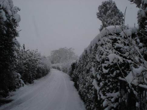
Almost every corner of the UK woke up to between 0.8in (2cm) and 4in (10cm) of snow this morning, with the east coast worst hit by flurries and sub-zero temperatures.
And the cold blast from the North Sea was expected to continue to batter eastern areas throughout the day, even bringing snow to London and the South East.
Tiffany Curnick, a forecaster with MeteoGroup, the weather division of the Press Association, said: “Last night we had snow showers coming in from the east becoming more widespread and giving some quite significant accumulations, especially in northern England and southern Scotland.
“Today, we have got the same easterly flow bringing in snow showers from the east but the showers are probably going to be more widespread across England and Wales.
“We’ve still got these showers streaming in from the east bringing some further accumulations of snow.
“The areas that won’t be affected are Cornwall and western Scotland – anywhere sheltered from the easterly winds.”
Severe weather warnings were issued by the Met Office for almost all regions with London, the South East, the East of England, the East Midlands, the West Midlands, Yorkshire and Humber, the North East, North West and Wales all on alert for heavy snow well into the morning.
Grampian, Strathclyde, Tayside and Fife, south-west Scotland, Lothian and Northern Ireland were all warned to expect widespread icy roads.
Temperatures in the north-west Highlands dropped to minus 15C (5F) last night, with the Met Office warning the mercury will barely rise above 0C (32F) for the rest of the day.
Met Office forecaster Tom Morgan said: “Overnight, we’ve had some outbreaks of snow and a lot of the country has seen some snow showers with accumulations of 2.5cm (1in) in the South East and East of England.
“Temperatures today are going to be very cold and we’re looking at 1C (33.8F) to 2C (35.6F) with a very strong north-easterly wind.
“In towns or cities, we’re looking at minus 2C (28.4F) to minus 4C (24.8F) tonight, dropping to minus 6C (21.2F) or minus 8C (17.6F) in less sheltered parts.
“The worst-affected areas will be eastern parts of the country and perhaps Kent and Essex and the North East.
“In terms of this week, the cold spell is going to continue but will be less widespread as we go through the week.”
Yesterday, thousands of motorists were hit by one of the worst days on Britain’s roads, flights were cancelled and hundreds of schools were forced to close.
The AA said it was one of its busiest on record after it was called to more than 20,000 breakdowns, but today could rival it.
Edinburgh Airport reopened this morning after closing at 6.15pm last night but a number of flights arriving and departing from the snow-stricken transport hub faced disruption. Walesonline.com
 del.icio.us |
 Digg
Digg


Post your comment